A Case Study for the Importance of Hydrography
By Richard Sanders, NORCE | December 7, 2023
With contributions from Are Olsen
As global leaders and decision makers gather in Dubai for COP28, it is timely to reflect on the role that the ocean plays in mitigating climate change and how ship-based, ocean observations (i.e., those performed by GO-SHIP) contribute to our understanding of this key process.
We all know that climate change is one of the most crucial issues facing humanity, and that this is caused by the accumulation of greenhouse gases in the atmosphere, with CO2 emissions from the burning of fossil fuels being a major causal factor.
However, what is less well known is that detailed analyses of fossil fuel emission statistics and atmospheric concentrations conducted by the Global Carbon Project, and presented each year at the COP, shows that only about half of the CO2 we have emitted (termed Anthropogenic Carbon) remains in the atmosphere.
The rest has been absorbed and is now stored by other parts of the Earth system, the ocean and vegetation on land (see figure below taken from the Global Carbon project, which shows the fate of anthropogenic carbon emissions over the last decade). Their current best estimate shows that these two sinks contribute approximately equally to this storage.
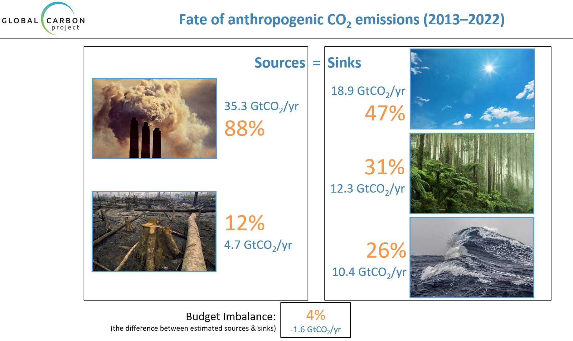
Tracking down the exact location of this ‘missing carbon’ is important for climate change research and for developing mitigation strategies because a) different CO2 storage reservoirs have different levels of security, (for example CO2 might be more easily lost from the land reservoir than the ocean as a consequence of wildfires) and b) the mechanism by which the absorption into the reservoirs happen may be sensitive to climate change. In a worst-case scenario, a sudden release of stored carbon or a drastic reduction in uptake could cause a large change in atmospheric CO2 concentration, even if emissions were declining or had stopped completely.
We have a variety of techniques at hand to determine the location of this missing carbon including field surveys, satellite information and numerical models. Field surveys include both surface observations to estimate the magnitude and location of surface uptake and are used in the Global Carbon Budget and the whole ocean depth surveys, conducted by GO-SHIP, give a more integrated perspective and reveal where in the ocean the missing carbon is stored.
GO-SHIP surveys can be conducted relatively quickly on a research vessel. For example, we can survey an entire transect of the Atlantic, from surface to bottom, with 15 people on a ship in a period of a month. Such surveys make observations approximately every 50 kilometres across the ocean to a depth of up to 5 kilometres with water samples being captured every 10 to 50 metres in the surface and further apart at depth.
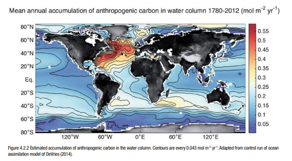
The smoothness of the gradients within the ocean, coupled to the well characterized nature of seawater chemistry has allowed us to develop methods to separate natural and anthropogenic carbon. As a result, our sampling resolution provides a good overall picture of natural and anthropogenic ocean carbon stores, and we now have several surveys of the ocean, conducted approximately every 10 years that we can use to estimate ocean CO2 uptake at the basin scale.
These observations show that CO2 emissions in the atmosphere dissolve in the sea surface and penetrate the deep ocean over time. They also reveal the geographical pattern of storage (figure below) with important reservoirs occurring in the North Atlantic and the Southern Ocean.
Going forward an increased contribution to all these calculations will be made using data from autonomous platforms, called floats. Currently there is a large fleet of these devices patrolling the oceans operated by the Argo Network. These have the ability to sample the whole ocean on a year-round basis. However, they do not directly measure ocean carbon concentrations and hence we need high quality in situ data to calibrate float-based estimates. These high quality in situ data can only be provided by research vessels and hence GO-SHIP will remain a core component of the ocean carbon observing system and projects like EuroGO-SHIP will contribute to enhance European contributions to the system and bring important new services in support of this vital community, in Europe and beyond.

About the author
Name: Richard Sanders
Work Package: WP 2, 4-6
Organisation: NORCE, Norway