A EuroGO-SHIP Success Story
By Fiona Carse, Met Office | March 26, 2024
Contributions by Tim Smyth (Plymouth Marine Lab) and Matthew Martin (Met Office)
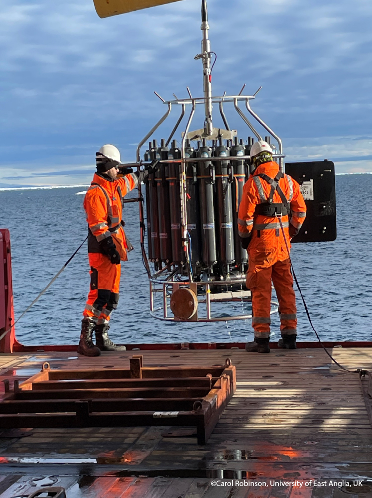
From sea surface to seabed, vessels on GO-SHIP research cruises provide the most accurately calibrated and quality-controlled measurements of the ocean’s physical and biogeochemical properties in the world.
These datasets are crucial for our understanding of the ocean, including its role in global climate.
CTD measurements in operational ocean forecasts
The ‘workhorse’ instrument for research cruises is the CTD—conductivity, temperature, depth. It generates depth profiles of temperature and salinity, which are key measures of the physical state of the ocean.
Approximately ten years ago, colleagues in the hydrography and forecasting communities, including EuroGO-SHIP’s Tim Smyth of Plymouth Marine Lab, collaborated to begin a new era of extracting value from research data in real-time. Acknowledging that temperature and salinity profiles from CTD instruments on board research vessels were likely to be higher quality than data from autonomous platforms (such as Argo floats, gliders, moored buoys and tagged animals) deep ocean CTD observations made by researchers can now be assimilated into ocean and weather forecast models within one to two hours of collection. This rapid data transfer became possible as internet connectivity improved on vessels.
When the EuroGO-SHIP project started in December 2022, France, Germany, Norway and the UK had already begun releasing real-time CTD data from research vessels. One of EuroGO-SHIP’s aims is to encourage and support more vessels submitting real-time data. By 2024, EuroGO-SHIP scientists have helped three new vessels to adopt the process: The Sir David Attenborough, Corystes and Plymouth Quest, operated by the UK, and we are currently in detailed discussions with Ireland’s Marine Institute to install a real-time data transfer system on their vessel.
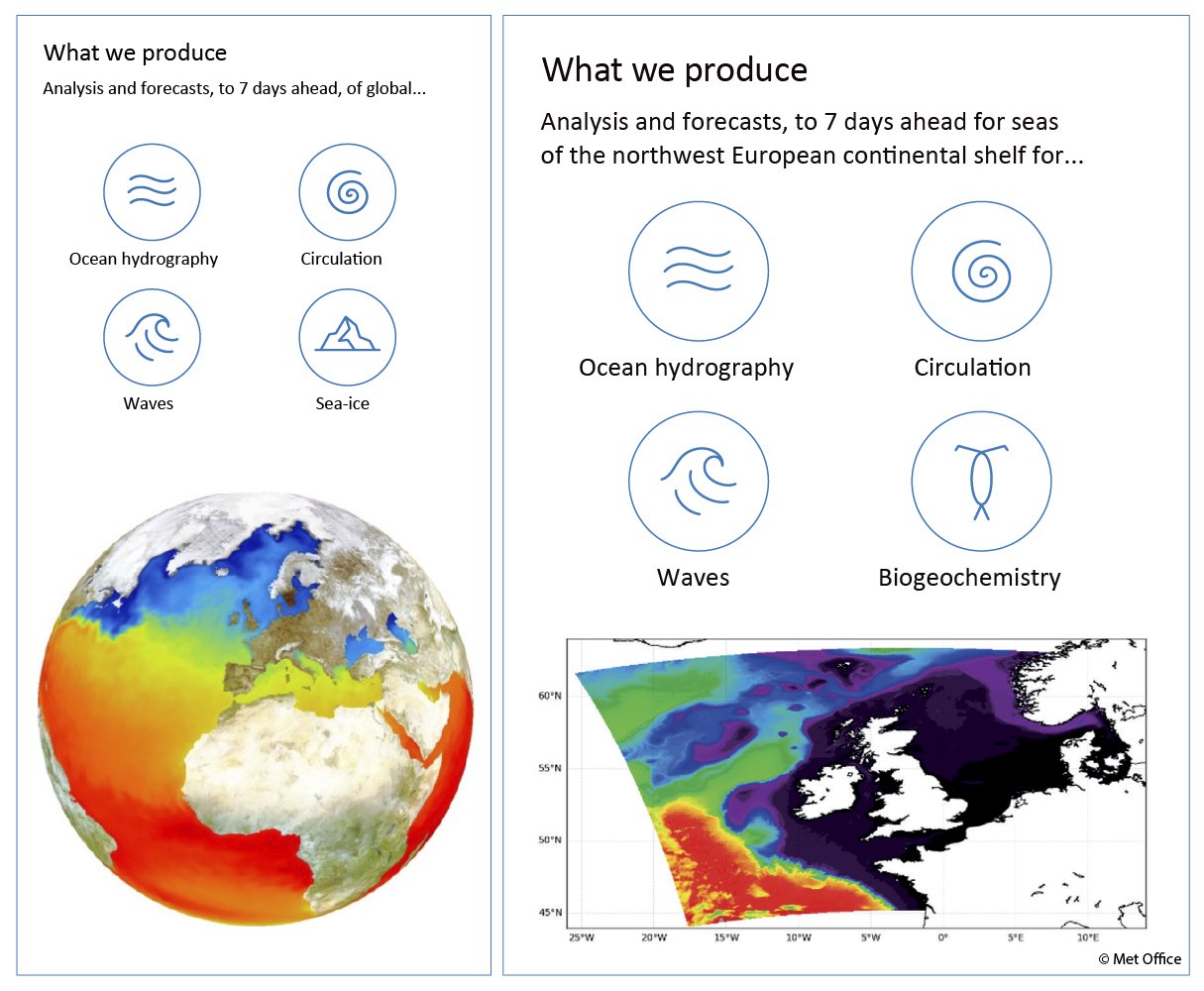
What is an ocean forecast?
A 4-dimensional representation of the present and predicted state of the ocean, ocean forecasts provide accurate estimates of temperature, salinity and currents, both at the surface and throughout the water column. This is crucial information for all maritime navigation planning and a range of technical and safety aspects of offshore industries. Likewise, planning and operation of underwater pipelines transporting gas and electricity requires seabed temperature information, just as naval operations rely on knowledge about the vertical structure of the ocean density.
Since the ocean also influences atmospheric variables, ocean forecasts are produced as part of coupled weather forecasts by national weather services around the world. Institutes like EuroGO-SHIP partner Met Office (UK) combine real-time CTD observations with numerical models to provide up-to-date ocean forecasts seven days and beyond.
How observations are used in ocean forecasts
Real-time observations make forecast models as close to ‘the truth’ as possible. Complex maths is used to adapt the model based on the previous day’s forecast, the real-time observation values and the error characteristics of the model and observations. Real-time observations from both satellites and measurements from in-situ platforms are assimilated by Met Office forecast models.
Gaps in observation with the existing networks
Satellite observations provide excellent spatial coverage of surface ocean temperatures. But even with the amazing advances made by the Argo floats, gliders and tagged animal programmes in the last 20 years, profile measurements to the deep ocean are far rarer and have wide gaps. Notably, most instruments do not measure below 2,000 m, and Argo floats are not usually deployed in waters shallower than 2,000 metres, meaning that many coastal and shelf seas are not well observed despite being important regions for humans. And although ice-avoidance algorithms have been developed for floats, there are still significant gaps in seasonally ice-covered regions of the ocean. In Europe, gliders are used to survey the shallower shelf seas, but these are still very sparse.
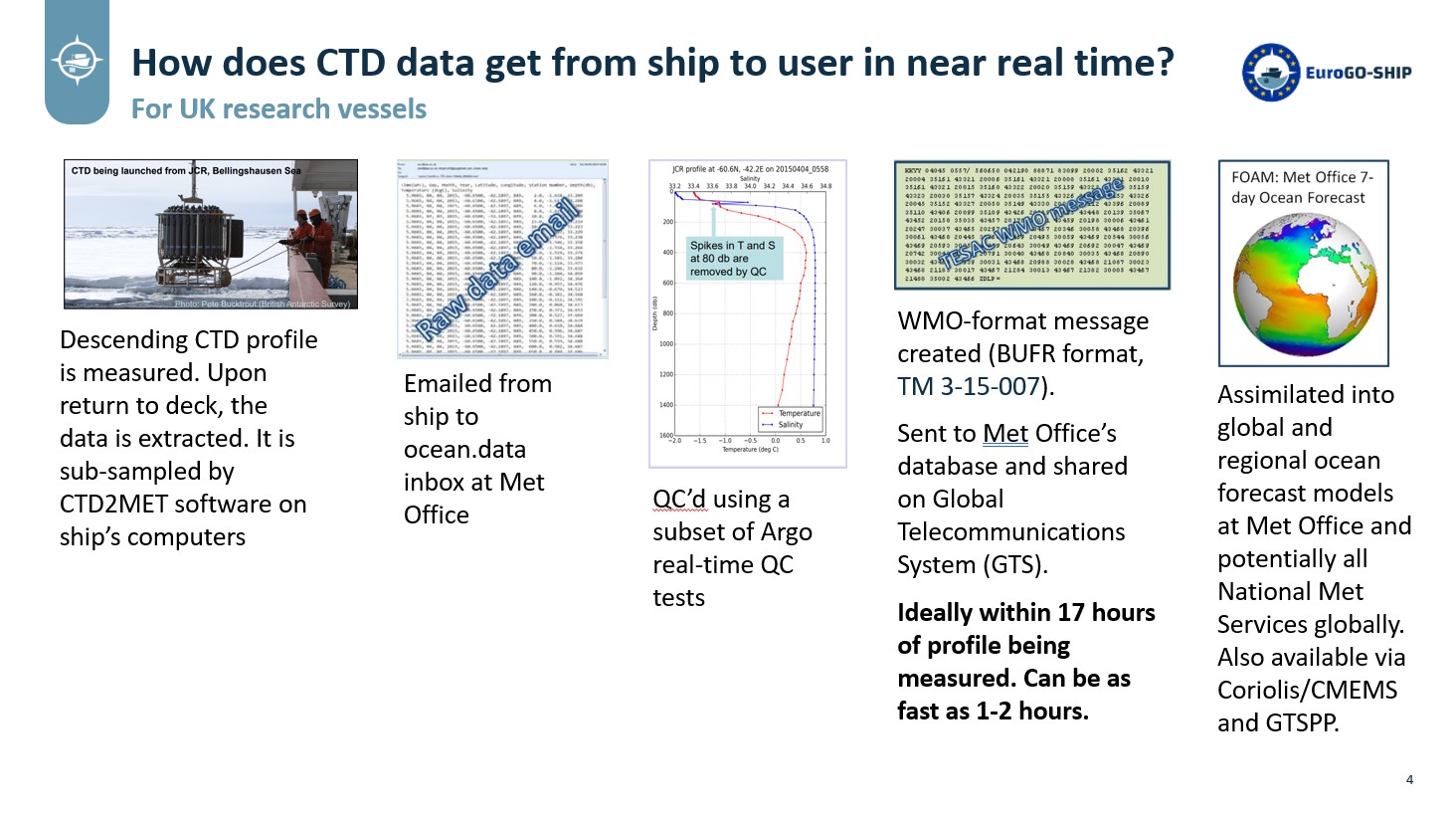
How data reaches the ocean forecasting system
Different nations use different methods to transfer real-time CTD data from ship to shore. In the UK, the temperature and salinity profiles are sub-sampled and sent by email to the Met Office where they are quality controlled using automated Argo-like procedures, converted into a WMO format called BUFR, then simultaneously routed into the Met Office’s database and shared globally with all Met Services using the WMO’s Global Telecommunications Service.
How much does the real-time CTD data help to improve ocean and weather forecasts?
A robust Observing System Experiment (OSE) to evaluate the impact of a set of observations hasn’t, to the best of our knowledge, been conducted on research CTD data. This is due to the fact that OSEs are expensive to run in terms of supercomputing and staff cost because large global models must be run both with and without the dataset of interest for comparison.
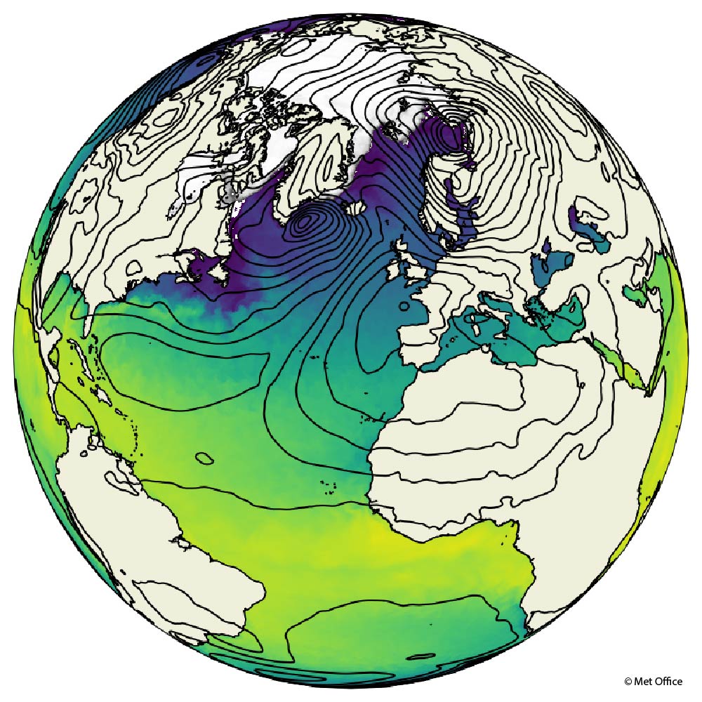
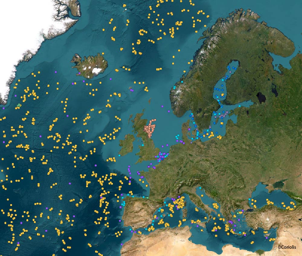
Nevertheless, we know that real-time research vessel data adds value to forecasts because the vessels often make observations in regions that are not well observed by other platforms. For example, Figures 3 and 4 below show all data available in real-time in June and December 2023 for Europe. Since many observing platforms do not make daily observations (e.g., Argo floats measure a profile once every 10 days), the daily runs of Met Office models face significant data gaps. The lack of in-situ profile observations in the busy waters of Europe’s North West Shelf are particularly noticeable, especially since many research vessels operate in this area. At the Met Office, we assimilate all available real time CTD data into our forecast models because it helps to fill these gaps. If we could assimilate more research vessel real-time CTD observations, this would likely improve ocean and weather forecasts, helping for instance to detect Marine Heatwaves and predict their impact on weather (Berthou et al., in prep. 2024).


The Met Office runs a global short-range coupled ocean-atmosphere forecast at about 04:00 UTC every day, producing a seven-day forecast. It has a horizontal resolution of 0.25 degrees (which is about 28 x 28 km at the equator and 16 x 28 km at 55 N). The model covers the full depth of the ocean, with 75 variable-depth levels, thinner at the surface becoming progressively thicker near the seabed. The time step of the model is 20 minutes. Every 20 minutes between time = 0 and time = +7 days, a 3D grid of values is produced. Each grid box contains a predicted value of temperature, salinity and horizontal current speed and direction at different forecast times. The ocean is run within a coupled ocean/atmosphere model which means that the upper layers of the ocean model influence the atmospheric forecast model, and the atmospheric model affects the evolution of the ocean model. The Met Office also runs a series of nested models, covering smaller areas at higher spatial resolution. For example, the AMM15 model runs daily for the European Northwest Shelf region, at 1.5 km resolution. This 5 minute video introduces the Met Office’s ocean forecasting systems.
The three-year HORIZON EUROPE EuroGO-SHIP seeks to enable the European community conducting ship-based hydrographic observations at sea to provide higher quality and more sustainable data flows to a broad range of end users, more effectively. The project is funded under the call HORIZON-INFRA-2022-DEV-01-01: Research infrastructure concept development.

About the author
Name: Fiona Carse
Work Package: WP 2, 4, 5
Organisation: Met Office

Name: Matthew Martin
Matt is a Science Fellow at the Met Office, where he leads the research and development of marine data assimilation systems